Radar Earth Terremoto
- 4.1
- Rating
- 50.00K
- Installs
- Free
- Price
 Analysis by App-foxy
When I open a weather app, I usually want an answer quickly: is something happening near me, and is there a reason to pay attention? Radar Earth Terremoto takes a narrower route than a general forecast app. It is built around earthquake alerts, live seismic maps, and information about individual events, making it more useful for people who want seismic activity in one focused place rather than buried inside a broader weather dashboard.
I approached it as a decision rather than a simple download recommendation. An earthquake app has to do more than display an attractive map. It needs to help me understand what I am seeing, avoid unnecessary alarm, and fit naturally into the way I check information during an ordinary day. Radar Earth, from the developer alerta inminente, has a clear purpose and a free entry point, but its value depends heavily on whether earthquake monitoring is something I genuinely need.
How I would decide whether Radar Earth fits
The first question is how often I need seismic information. If I live in an area where earthquakes are a realistic concern, a dedicated tool can deserve a place on my phone. If I only want rain forecasts, temperature trends, or storm tracking, this app is not a substitute for a full weather service. Its focus is much more specific, and that focus is both its main strength and its first limitation.
You May Also Like

 Pandora - Music & Podcasts
Pandora’s Music Is Easy to Start, but Harder to Recover
Pandora’s strength is its low-effort path from a seed to a station. Its weak spot is how much confidence it asks you to place in connection, setup, and quiet recovery.

 8 Ball Pool
 Is Built on Rivalries, Rematches, and Routine
A close look at the rivalries, rematches, shared routines, and unanswered safety questions that turn a quick pool match into a persistent mobile community.

 Samsung Music
’s Quiet Strength Is Playing What You Already Own
Its reach comes less from spectacle than from dependable access to a personal library. That simplicity is both the app’s strongest retention engine and its ceiling.

 AccuWeather: Weather Radar
AccuWeather Review: A Quick, Clear Forecast for Everyday Decisions
For everyday plans, the best forecast is the one you can understand quickly. AccuWeather makes rain timing, radar, and local conditions easy to act on, with a few trade-offs.

 Hill Climb Racing
Why Hill Climb Racing Still Turns Crashes Into One More Run
A tiny car, a bumpy hill and one more upgrade: Hill Climb Racing keeps resurfacing because its simple chaos makes every near-miss feel personal.

 AliExpress - Shopping App
AliExpress Makes Global Shopping Feel Personal, but Shoppers Bear the Risk
AliExpress turns a global marketplace into a pocket-sized discovery engine. Its reach is useful, its shopping loop compelling, and its trade-offs easy to miss.
More From Our News Desk
View All News


The next question is how I prefer to consume information. Some people want a single notification and then move on. Others want to inspect a map, compare nearby events, and read the details attached to a tremor. Radar Earth is aimed more at the second group. Its combination of alerts, a live seismic map, and event information suggests a workflow in which I can notice an event and then investigate it instead of treating the notification as the entire experience.
I would also consider whether I need a tool for personal awareness or for formal emergency planning. An app can help me notice activity and understand reports, but it should not replace local emergency instructions, official warnings, or a household preparedness plan. That distinction matters because earthquake information can change quickly, and no phone application should be treated as a guarantee of advance warning.
On compatibility, the app is available for Android devices running version 7.0 or later. That makes it practical for people who keep an older phone, although the experience will naturally depend on the device and operating system. The current release is version 1.0.162, so I would keep the app updated rather than relying on an old installation when the purpose is timely information.
The basic download is free, which removes the biggest barrier to trying it. There are also optional in-app purchases ranging from $0.99 to $9.99 per item. I would not assume that every useful function requires payment, but I would check the purchase screen before committing to any paid option. For a casual user, the free starting point is important; for someone who expects to use the app as a serious monitoring tool, the cost of optional extras should be part of the decision.
The app is rated for Everyone, which makes its presentation approachable for a broad audience. That does not mean every earthquake-related situation will feel comfortable for every user. A stream of seismic events can make an anxious person check the phone repeatedly, so I would use it as an information aid rather than turning every small event into a reason for alarm.
What I look for during the first session
My first test would be simple: can I understand the main screen without searching through menus? A useful opening experience should make the current seismic picture easy to find, then let me move from the map to a specific event without losing context. I would pay attention to whether the map is readable at the zoom level I normally use and whether event information is presented in plain language rather than as a wall of technical labels.
I would also test the difference between seeing an event and receiving an alert. Those are not the same thing. A map is something I consult; an alert is something that interrupts me. Before relying on notifications, I would check which alert controls are available on my phone and decide whether I want every nearby report or only information that is more relevant to my location. This is one of the most practical habits for avoiding notification fatigue.
Another useful test is to open an event after the initial moment of interest has passed. That reveals whether the app works as a reference tool, not just as a live feed. If I can return to an event and understand its location and surrounding context, the app becomes more valuable for learning local patterns and discussing an incident with family or colleagues.
Where its focused design works best
The strongest part of Radar Earth is its specialization. A broad weather application may offer a little information about many conditions, while this app puts seismic activity at the center. That makes the purpose immediately clear. When I am specifically wondering about an earthquake, I do not have to navigate through radar imagery, hourly forecasts, pollen readings, or unrelated weather panels.
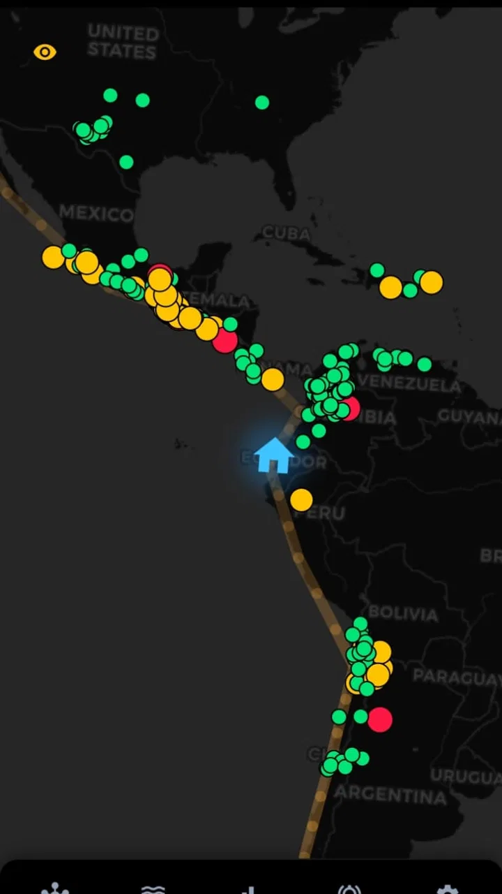
The live seismic map is especially useful for visual thinkers. Reading that an event occurred somewhere is one thing; seeing its position relative to my city, a family member, or a route I use regularly is more informative. The map can turn an abstract report into geographic context. I would use it after feeling a tremor, after hearing reports from another area, or when checking whether several events are clustered in a region that matters to me.
Event information adds a second layer. A map is good for overview, but it can leave important questions unanswered: which event am I looking at, how close is it, and is it the same incident people are discussing? Moving from the visual display to the event details is the workflow I find most convincing here. The real advantage is not merely seeing dots on a map; it is connecting an alert to a specific event and its location.
There is also a useful psychological benefit to having one dedicated place to check. After a noticeable tremor, people often jump between social media posts, search results, and general news pages. That can produce duplicated or contradictory impressions. A focused seismic app gives me a more orderly first stop. I can check the map and event information before deciding whether I need to look for local instructions.
For families, I see a practical use in agreeing on a simple checking routine. Rather than everyone forwarding unverified messages, one person can look at the event view and share the relevant location context. This does not turn the app into an emergency coordination system, but it can reduce confusion during the first few minutes after a tremor.
A realistic everyday scenario
Imagine I am at home in the evening and feel a short vibration. Nothing appears damaged, but a family member in another room asks whether it was an earthquake. I would open Radar Earth, check the live seismic map, and look for an event near our area. If an alert or event appears, I would open its information rather than relying on a cropped notification. That helps me distinguish between a nearby report and activity that only looks close when viewed on a broad map.
If the event is far away, the app can provide reassurance without requiring a long search. If it is nearby, I would stop using the app as my only source and move to local safety guidance, checking the surroundings and contacting people who may need help. The app is useful in the first step of understanding what may have happened; it is not the entire response plan.
A second scenario is less dramatic. I might hear about an earthquake during a commute and want to know whether it occurred near a place I am about to visit. The map gives me a geographic view, while the event information helps me avoid confusing a distant incident with one in my immediate area. This is a good example of why a specialized tool can be more convenient than a general weather app, even when no emergency is unfolding.
Where a general weather app or another source may fit better
Radar Earth is not the right choice if my main need is an all-purpose forecast. Someone who wants hourly rain predictions, wind details, air quality, or travel weather will probably be better served by a conventional weather application designed around those tasks. Adding a seismic app may create two places to check, but that separation is reasonable when earthquake information matters enough to deserve its own attention.
It may also be a poor fit for someone who wants only official emergency instructions. In that case, local government channels and emergency services should take priority. The app can complement those sources by helping me understand seismic events, but I would not use it as a replacement for instructions about evacuation, shelter, utilities, or building safety.
Users who dislike maps may find the central presentation less comfortable than a simple notification service. A map rewards curiosity and comparison, but it can also encourage repeated checking. If I only want a quiet background alert, I would compare the app’s notification behavior with my own tolerance for interruptions before enabling everything.
There is another trade-off for people who travel frequently. A dedicated earthquake tool can be valuable when visiting seismic regions, but its usefulness depends on whether the places I care about are represented clearly and whether the event information is understandable while I am away from home. I would test it in advance of a trip instead of waiting until a tremor creates pressure to learn the interface.
It is also worth separating live awareness from prediction. I would never interpret an alert or map marker as a promise that another earthquake will happen, nor would I treat a quiet screen as proof that nothing can happen. The app’s role is to help me see reported seismic activity and event context. That is useful, but it is fundamentally different from forecasting the future.
Small habits that make the app more useful
My first practical tip is to establish a location reference before an event occurs. I would learn how my home area appears on the map and note the zoom level that makes nearby places easy to identify. During a stressful moment, that familiarity saves time and reduces the chance of misreading a broad regional view.
Second, I would avoid treating every notification as an instruction to investigate immediately. I would decide in advance which alerts deserve attention and which can wait until I am free. This is especially helpful for people who become anxious when they see frequent seismic reports. A notification system works best when it informs my routine rather than taking control of it.
Third, I would use the event view to build geographic understanding, not just to react. Looking at where events occur relative to familiar places can help me interpret future reports more calmly. The point is not to become a seismologist; it is to learn the difference between a nearby event, a regional event, and a marker that only seems close because the map is zoomed out.
Fourth, I would keep a separate emergency checklist. The app may tell me that an event has been reported, but it cannot inspect my building, confirm whether utilities are safe, or tell me what a local authority requires in a specific situation. Keeping a flashlight, knowing exits, and having a family contact plan remain more important than any single screen.
Finally, I would review optional purchases with a specific purpose. Since paid items range from $0.99 to $9.99, I would not buy an add-on simply because I use the app often. I would first identify the problem it solves, then decide whether that improvement matters to my routine. This keeps a free monitoring tool from becoming an unnecessary recurring expense in my mind.
What switching to it really involves
Moving from a general weather app to Radar Earth is not a complete replacement; it is a change in emphasis. I would still keep a normal weather service if I need forecasts, while using this app for seismic awareness. The cost of switching is therefore mostly attention and setup rather than abandoning everything familiar. I need to learn a new map, decide how I want alerts handled, and remember which app answers which question.
For someone already using a dedicated earthquake service, the decision is more demanding. I would compare the clarity of the map, the usefulness of event information, and the practical behavior of alerts rather than choosing based only on the presence of a seismic feed. If the existing service already gives me the context I need without friction, changing may not be worthwhile. Radar Earth becomes more attractive when I want a focused alternative that is free to try and easy to evaluate on my own phone.
The app’s audience gives some indication of its accessibility. It has passed fifty thousand installs and holds a 4.1 average from roughly three hundred ratings, so it is not an unknown experiment with no public use at all. I would treat those figures as a reason to try it, not as proof that it will suit every location or personal preference. My own experience with the map and alerts would matter more than popularity alone.
Because the app is free and rated for Everyone, trying it is relatively low risk financially. The more important cost is whether it adds useful clarity or simply another stream of information. If I already feel overwhelmed by alerts, I would install it only if I am willing to configure it thoughtfully. If earthquakes are a meaningful concern in my area, that small setup effort seems justified.
My recommendation for different kinds of users
I recommend Radar Earth to Android users who specifically want a dedicated way to follow earthquakes, inspect a live seismic map, and open information about individual events. It is particularly suitable for someone who finds general weather apps too broad and wants seismic activity to be immediately visible. The free starting point makes it easy to test without making a financial commitment, while the focused design gives it a clear role on the phone.
I would be more cautious recommending it to a person looking for a complete weather companion, a formal emergency alert authority, or a prediction tool. Those needs call for different resources, and adding this app will not solve them by itself. I would also hesitate if notifications tend to increase anxiety, unless the user is comfortable limiting them and checking the map on their own terms.
After using it as a decision tool rather than a novelty, I see the best value in its workflow: notice an alert, locate the event, read its context, and then decide whether any real-world action is needed. That sequence is more useful than simply watching a feed. If earthquake awareness is your specific need, Radar Earth is worth installing and testing; if it is not, its specialization will feel like unnecessary clutter.
Radar Earth Terremoto is a free weather-category app from alerta inminente, released on July 27, 2026, and its current version is 1.0.162. Those details matter less than the central question: do I want a dedicated seismic view on my phone? For me, the answer is yes when I need quick geographic context and event information, provided I keep the app in its proper role. It can help me understand what has been reported, but good judgment still comes from combining that information with official guidance and sensible preparation.
FAQs for Radar Earth Terremoto
01What is Radar Earth Terremoto and what does it do?
Radar Earth Terremoto is an earthquake-monitoring app designed to help users follow seismic activity around the world. It typically presents recent earthquake reports on a map or in a list, with information such as location, magnitude, depth, and time. It is useful for staying informed, but it should be treated as an information tool rather than an official emergency alert system.
02Does Radar Earth Terremoto provide real-time earthquake alerts?
The app may display recent earthquake information and, depending on the device and available settings, can offer notifications for selected seismic events. However, delivery speed and accuracy depend on the data sources, internet connection, regional availability, and notification permissions. Users should not rely on the app as their only warning method and should also follow official local emergency services.
03Can I use Radar Earth Terremoto to monitor earthquakes in a specific location?
Yes, the app is generally intended to make regional monitoring easier by allowing users to view seismic events on a map or filter activity by area. You can use it to check earthquakes near your current location or another place of interest. Available filters, distance settings, and location features may vary between Android and iOS versions.
04Does Radar Earth Terremoto work without an internet connection?
Radar Earth Terremoto requires an internet connection to download updated earthquake reports, refresh maps, and receive new information. Some previously loaded data may remain visible temporarily through device caching, but offline functionality should be considered limited. For reliable monitoring, keep mobile data or Wi-Fi enabled and make sure the app is allowed to operate in the background.
05Is Radar Earth Terremoto accurate enough for emergency decisions?
The app can be helpful for quickly checking reported seismic activity, but earthquake information may be delayed, revised, or differ slightly between monitoring agencies. It should not replace instructions from government authorities, emergency services, or official geological organizations. If you feel an earthquake or receive an official warning, follow established safety procedures instead of waiting for the app to confirm the event.
Pros
- Clear earthquake alerts with location
- magnitude
- and depth details.
- Interactive map makes it easy to view recent seismic activity worldwide.
- Useful history data helps identify earthquake patterns in selected regions.
- Simple interface allows quick access to essential seismic information.
- Can support travel and emergency awareness in earthquake-prone areas.
Cons
- Alert timing may vary depending on data sources and network availability.
- Frequent notifications can become distracting during periods of high activity.
- Some advanced monitoring features may require a subscription or in-app purchase.
- Earthquake predictions are not possible
- so alerts cannot guarantee advance warning.
- Map and location features may increase battery and mobile data usage.

Radar Earth Terremoto
Gallery